Projects and papers by Martin Kompf
DIY
Weather station with Raspberry Pi, 1-wire temperature sensor and I²C barometer

The Raspberry Pi is a fully functional, small and power efficient computer. It is ideal for the realization of measurement and control tasks in the home. Several papers explain the structure of a weather station with the Raspberry Pi:
The air pressure is measured with a barometer based on the I²C air pressure sensor BMP085. The article 1-wire temperature sensor DS1820 on Raspberry Pi (GPIO directly) describes how to connect a temperature sensor to the GPIO port. A solution to use the USB Weather Data Receiver USB WDE1 of ELV and the use of RRDTool for long-term data recording shows Weather data acquisition with the USB WDE1.
Tracks and maps
Distance calculation
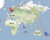
The article Distance calculation shows how to compute the exact straight line distance between two points from the geographic coordinates provided by the GPS. In addition, there is now a tool for displaying how the crow flies. After selecting two points on a map, the tool displays the distance in kilometers, miles and nautical miles. On the map you can see also the shortest path between points - the great circle distance.
GeoPosition
GeoPosition computes, shows, and converts geographic (GPS) coordinates using formats degree, minute, seconds, decimal degree, and UTM (WGS-84). It determines the time zone from coordinates and displays the times of sunrise and sunset for every place on earth. Elevation data are also available for the whole earth.
It is also possible to display the course of day and night across the earth for the current time.
GPS, GPX, KML, OVL, PCX5 Track Viewer | GeoPosition
C++
OpenCV practice: OCR for the electricity meter

OpenCV (Open Computer Vision) is a powerful and comfortable environment for the realization of a variety of projects in the field of image processing. This tutorial introduces some aspects of OpenCV based on a practical application - the reading of an electricity meter:
In many homes there are still electricity meters with a mechanical counter that do not provide a direct, standardized interface for reading the consumption of electrical energy with a computer. One way to gain access to this data anyway, consists in the optical detection of the counter with a video camera and the subsequent character recognition. Read more
Java
Determine time zone with GeoTools from shapefiles
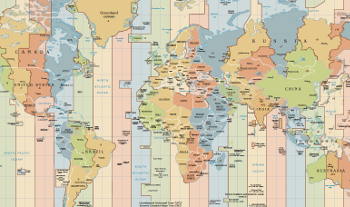
Time zones define the difference of the respective local time to Greenwich Mean Time (GMT) and the rules for daylight saving time changeover. With the existing possibilities of global online exchange of data and information, the exact knowledge of the time zone of the communication partner plays a major role in order to avoid misunderstandings and errors.
The article describes the implementation of a RESTful web service to determine the time zone from geographical coordinates using Java, GeoTools and shapefiles. Read more